[vc_single_image image=”18034″ img_size=”full” alignment=”center”]
Author: Imported Author 2289001
-
Gunner Maxie
[vc_single_image image=”1514″ img_size=”large” alignment=”center”][vc_single_image image=”1515″ img_size=”large” alignment=”center”][headerText widget_name=”Birthday and Anniversary Cakes Provided By The Markets” level=”h3″ url=”” el_class=””]
Happy Birthday to Gunner Maxie!
Birthday Cake winner 4/5/22
-

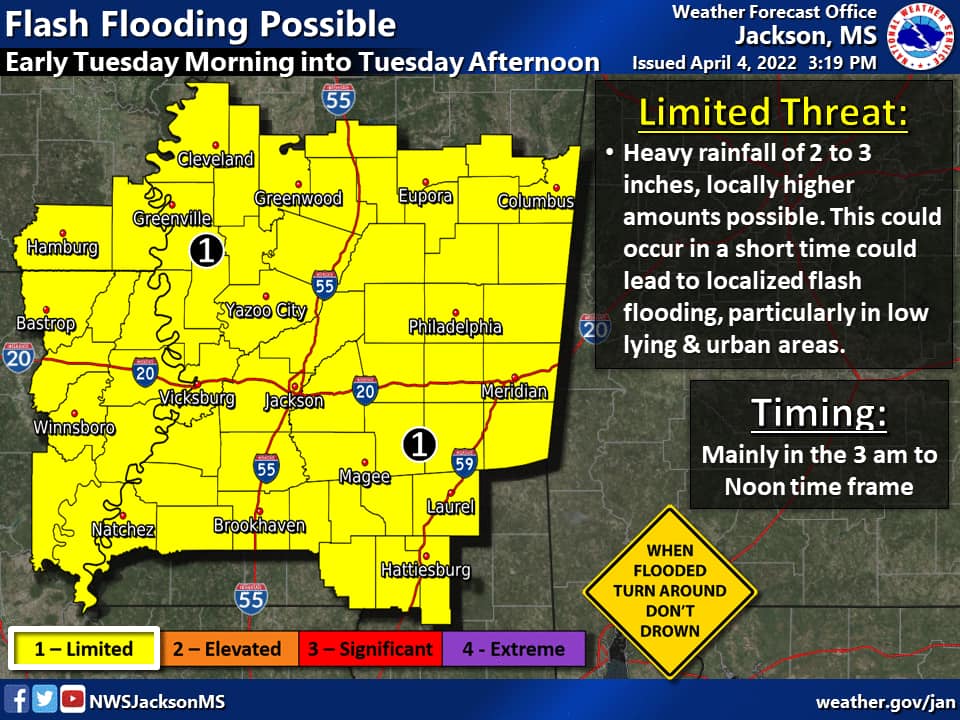
Likely Severe Weather for early morning hours of Tues., April 5
Tues, April 5th @ 5:50AM: Adams Co. is under a Severe Thunderstorm Warning untilThe Adams Co. Safe Room at 323 Liberty Road will be open until 11AM today.All NASD schools will delay opening until 10AM.ACCS will start at 8AM, as scheduled, but will not count tardies today.Concordia Parish Schools are delaying the start of school until 10AM.All Co-Lin Community College campuses will delay opening tomorrow at 10AM.Natchez city offices will delay opening until 9AM on Tuesday.____The Adams County Emergency Management Agency is monitoring the situation and will keep us updated.Natchez-Adams County residents can self-fill sandbags at the following locations until 5:30pm, today, April 4th.County Residents can go to the Foster Mound Volunteer Fire Department on 228 Foster Mound Road or The Adams County Maintenance Shop on 35 Marjaco Road.City Residents can go to The City of Natchez Public Works Department on 233 1/2 Devereaux Drive, please enter on Old Washington Road.For all three locations, you must bring your own shovel. NO shovels will be provided for usage.Stay tuned to 95 Country for updates on weather or the potential for delayed openings.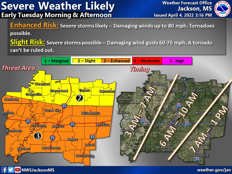
-
Bryce McGlothin
[vc_single_image image=”18034″ img_size=”full” alignment=”center”]
Congratulations to Bryce McGlothin for being our person of the day!
4/4/22
-
Ashlyn Wiley
[vc_single_image image=”1514″ img_size=”large” alignment=”center”][vc_single_image image=”1515″ img_size=”large” alignment=”center”][headerText widget_name=”Birthday and Anniversary Cakes Provided By The Markets” level=”h3″ url=”” el_class=””]
Happy Birthday to Ashlyn Wiley!
Birthday Cake winner 4/4/22
-
Wills Simpson
[vc_single_image image=”1514″ img_size=”large” alignment=”center”][vc_single_image image=”1515″ img_size=”large” alignment=”center”][headerText widget_name=”Birthday and Anniversary Cakes Provided By The Markets” level=”h3″ url=”” el_class=””]
Happy Birthday to Wills Simpson!
Birthday Cake winner 4/1/22
-
Michelle Crouch
[vc_single_image image=”1514″ img_size=”large” alignment=”center”][vc_single_image image=”1515″ img_size=”large” alignment=”center”][headerText widget_name=”Birthday and Anniversary Cakes Provided By The Markets” level=”h3″ url=”” el_class=””]
Happy Birthday to Michelle Crouch!
Birthday Cake winner 13/30/22
-
Michelle Crouch
[vc_single_image image=”1514″ img_size=”large” alignment=”center”][vc_single_image image=”1515″ img_size=”large” alignment=”center”][headerText widget_name=”Birthday and Anniversary Cakes Provided By The Markets” level=”h3″ url=”” el_class=””]
Happy Birthday to Michelle Crouch!
Birthday Cake winner 3/31/22
-
Robbie Shell
[vc_single_image image=”1514″ img_size=”large” alignment=”center”][vc_single_image image=”1515″ img_size=”large” alignment=”center”][headerText widget_name=”Birthday and Anniversary Cakes Provided By The Markets” level=”h3″ url=”” el_class=””]
Happy Birthday to Robbie Shell!
Birthday Cake winner 3/30/22
-

ALERT DAY 3/30/22 – Weather Info and Closures
[headerText widget_name=”Power Outage Maps” level=”h3″ url=”” el_class=””]
Entergy Outage Maps: https://www.entergy.com/view-outages/
Entergy Contact to report an outage or get status: 1(800) 968-8243
Call 911 in case of emergency!Concordia Electric Outage Map: http://cecdata.com/outageMap.html
Concordia Electric Contact #: 1(318) 339-7462Southwest Electric Cooperative Outage Map: https://southwestelectric.coop/outage-map/
Southwest Electric Cooperative Contact #: 1(800) 287-8564[headerText widget_name=”Closures for Wed., Mar. 30″ level=”h3″ url=”” el_class=””]Natchez City offices and Adams Co. offices will close at Noon today.
Natchez-Adams School District and Concordia Parish Schools have cancelled classes for today.
Adams County Christian School will dismiss early today, at 11AM for Pre-K & Kindergarten, at 11:15AM for 1st- 6th grades, and 11:30AM for 7th – 12th grades.
Cathedral Catholic School will dismiss at 11:30AM.
ALL Co-Lin Campuses will close at 11:30AM.
Holy Family will close at 11:30AM.
Hansel & Gretel will close at 11:30AM.
First Presbyterian Playschool is closed today.[headerText widget_name=”General Info” level=”h3″ url=”” el_class=””]Due to severe weather the Adams County Safe Room will be open March 30, at 8:00am. Please bring food, drinks, medication, a blanket, and any essential items. Small pets are welcome, but they must be in a kennel. The Adams County Safe Room address is 323 Liberty Road.
Mississippi Emergency Management Agency has a full list of shelters and safe rooms open or on standby today. The list will be updated throughout the day, as reported to MEMA.
https://www.msema.org/shelters-and-safe-rooms/
Information on current watches and warnings is listed below.[headerText widget_name=”Weather Info” level=”h3″ url=”” el_class=””]At 3:03 p.m. -Adams County is under a Severe Thunderstorm warning until 4:00 p.m.
HAZARD: 60 mph wind gusts
SOURCE: Radar indicated
IMPACT: Expect damage to roofs, siding, and trees.
____
The National Weather Service in Jackson, MS has issued a Tornado Watch for Adams County and 33 other MS counties, from 12:15 p.m. to 8:00 p.m. In Louisiana, the watch includes Concordia Parish and 8 other parishes.
From Mississippi Emergency Management Agency (7:30AM on 3/30):
Overnight the entire state’s risk for severe weather was upgraded to a Level 4 Moderate.
Damaging winds up to 80 mph and tornadoes can’t be ruled out today.
 Monitor the forecast today
Identify your safe spot
Stay off the roads if possible
Prepare for Power Outages and Debris on the RoadsFollow our friends Mississippi Department of Transportation for roadway conditions throughout the day
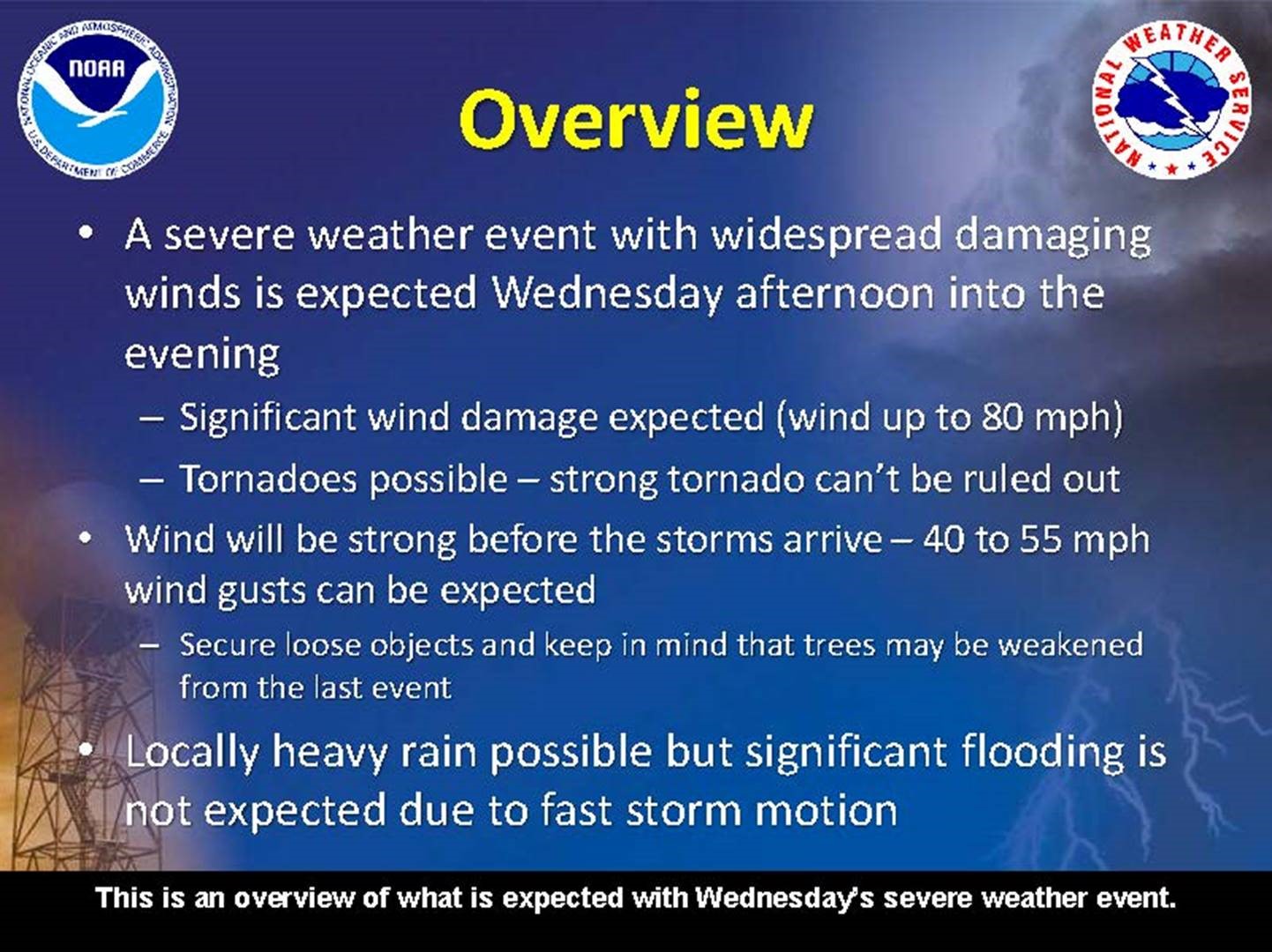
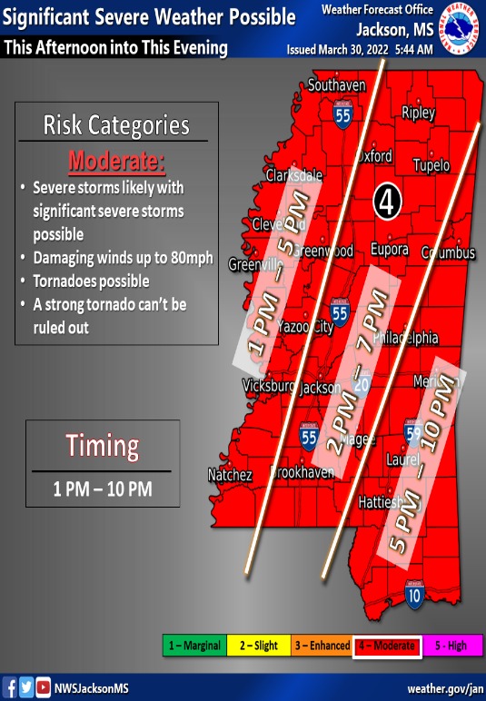
The National Weather Service in Jackson forecasts for Natchez a moderate risk of strong storms with damaging winds up to 80 mph and possible tornadoes for the hours of 1 to 5 p.m.
____
High Wind Warning
URGENT – WEATHER MESSAGE
National Weather Service Jackson MS
344 AM CDT Wed Mar 30 2022
Ashley-Chicot-Morehouse-West Carroll-East Carroll-Richland-Madison LA-Franklin LA-Catahoula-Tensas-Concordia-Bolivar-Sunflower-Leflore-Grenada-Carroll-Montgomery-Webster-Clay-Lowndes-Choctaw-Oktibbeha-Washington-Humphreys-Holmes-Attala-Winston-Noxubee-Issaquena-Sharkey-Yazoo-Madison MS-Leake-Neshoba-Kemper-Warren-Hinds-Rankin-Scott-Newton-Lauderdale-Claiborne-Copiah-Simpson-Smith-Jasper-Clarke-Jefferson-Adams-Franklin MS-Lincoln-Lawrence-Jefferson Davis-Covington-Jones-Marion-Lamar-Forrest-
Including the cities of Crossett, North Crossett, Hamburg, West Crossett, Dermott, Lake Village, Eudora, Bastrop, Oak Grove, Epps, Lake Providence, Rayville, Delhi, Tallulah, Winnsboro, Jonesville, Harrisonburg, Newellton, St. Joseph, Waterproof, Vidalia, Ferriday, West Ferriday, Cleveland, Indianola, Ruleville, Greenwood, Grenada, Vaiden, North Carrollton, Carrollton, Winona, Eupora, Mathiston, West Point, Columbus, Ackerman, Weir, Starkville, Greenville, Belzoni, Isola, Durant, Tchula, Lexington, Pickens, Goodman, Kosciusko, Louisville, Macon, Brooksville, Mayersville, Rolling Fork, Anguilla, Yazoo City, Ridgeland, Madison, Canton, Carthage, Philadelphia, Pearl River, De Kalb, Scooba, Vicksburg, Jackson, Pearl, Brandon, Richland, Forest, Morton, Newton, Union, Decatur, Conehatta, Meridian, Port Gibson, Crystal Springs, Hazlehurst, Wesson, Magee, Mendenhall, Taylorsville, Raleigh, Bay Springs, Heidelberg, Quitman, Stonewall, Shubuta, Fayette, Natchez, Bude, Roxie, Meadville, Brookhaven, Monticello, New Hebron, Prentiss, Bassfield, Collins, Mount Olive, Laurel, Columbia, West Hattiesburg, Lumberton, Purvis, and Hattiesburg
344 AM CDT Wed Mar 30 2022
…HIGH WIND WARNING IN EFFECT FROM 8 AM THIS MORNING TO 7 PM CDT
THIS EVENING…
* WHAT…South winds sustained 25 to 35 mph with widespread gusts to 55 mph expected. Isolated gusts up to 60mph. These winds will occur before the arrival of thunderstorms.
* WHERE…Portions of northeast Louisiana, central and south Mississippi and southeast Arkansas
* WHEN…From 8 AM this morning to 7 PM CDT this evening.
* IMPACTS…Damaging winds will blow down trees and power lines. Widespread power outages are possible. Travel will be difficult, especially for high profile vehicles.
PRECAUTIONARY/PREPAREDNESS ACTIONS…
People should avoid being outside in forested areas and around trees and branches. Winds of this magnitude can bring down trees and power lines causing serious injury and property damage. If possible, remain in the lower levels of your home during the windstorm, and avoid windows. Use caution if you must drive. Winds this strong will make driving difficult, especially for high profile vehicles. Secure outdoor objects.
____
Flood Warning
Flood Statement
National Weather Service Jackson MS
1049 AM CDT Wed Mar 30 2022
…The Flood Warning is extended for the following rivers in Mississippi…Louisiana…
Mississippi River At Natchez affecting Wilkinson, Concordia and Adams Counties.
PRECAUTIONARY/PREPAREDNESS ACTIONS…
Turn around, don`t drown when encountering flooded roads. Most flood deaths occur in vehicles.
Forecast includes rainfall on the ground and 48 hours of additional rainfall.
…FLOOD WARNING NOW IN EFFECT UNTIL LATE THURSDAY NIGHT…
* WHAT…Minor flooding is occurring and minor flooding is forecast.
* WHERE…Mississippi River At Natchez.
* WHEN…Until late Thursday night.
* IMPACTS…At 48.0 feet, Carthage Point Road becomes impassable.
* ADDITIONAL DETAILS…
– At 10:00 AM CDT Wednesday the stage was 48.5 feet.
– Forecast…The river is expected to fall below flood stage tomorrow morning.
– Flood stage is 48.0 feet.
____